


NEW ZEALAND AIP AMENDMENTS

AIPNZ Vol 4 Amendment Back Issue 26/2 - 19 FEB 26
Back Amendment for Volume 4 effective 19 February 2026.

AIPNZ Vol 4 Amendment Back Issue 26/6 - 11 JUN 26
Back Amendment for Volume 4 effective 11 June 2026.

AIPNZ Vol 4 Amendment Back Issue 26/4 - 16 APR 26
Back Amendment for Volume 4 effective 16 April 2026.
NEW ZEALAND AIP CONTENTS

New Zealand AIP Volume 4 - CONTENTS ONLY
AIP Volume 4 - CONTENTS ONLYIf you have not updated your AIP for sometime this is a good option if you still have a binder you wish to use.
Effective Date: 6 August 2026
This contents include...

New Zealand AIP Volume 1 - CONTENTS ONLY
AIP Volume 1 - CONTENTS ONLYIf you have not updated your AIP for sometime this is a good option if you still have a binder you wish to use.
Effective Date: 6 August 2026
This contents includes...
New Zealand AIP Volume 2 - CONTENTS ONLY (NOT including Vol 3 or Enroute Charts)
AIP Volume 2 - CONTENTS ONLYIf you have not updated your AIP for sometime this is a good option if you still have binders you wish to use.
Instrument flying in New Zealand requires both Volume 2...

New Zealand AIP Volume 3 - CONTENTS ONLY (NOT including Vol 2 or Enroute Charts)
AIP Volume 3 - CONTENTS ONLYIf you have not updated your AIP for sometime this is a good option if you still have binders you wish to use.
Instrument flying in New Zealand requires both Volume 2...
Charts

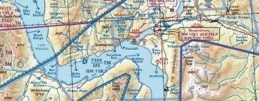
C11/C12 VNC Waikato/Buller - (1:250,000) - 27 November 2025
Effective 27 November 2025
This chart is 1:250,000 scale at an A1 sheet size and covers:
Waikato
Buller
Visual Navigation Charts (VNC) are intended for pre-flight planning and in-flight na...

C5/C6 VNC Napier/Gisborne/Auckland South - (1:250,000) - 27 November 2025
Effective 27 November 2025
This chart is 1:250,000 scale at an A1 sheet size and covers:
Napier/Gisborne
Auckland South
Visual Navigation Charts (VNC) are intended for pre-flight planning ...

C3/C4 VNC Auckland North/Hawke's Bay - (1:250,000) - 27 November 2025
Effective 27 November 2025
This chart is 1:250,000 scale at an A1 sheet size and covers:
Auckland North
Hawke's Bay
Visual Navigation Charts (VNC) are intended for pre-flight planning and ...

C1/C2 VNC Northland/Wellington - (1:250,000) - 27 November 2025
Effective 27 November 2025
This chart is 1:250,000 scale at an A1 sheet size and covers:
Northland
Wellington
Visual Navigation Charts (VNC) are intended for pre-flight planning and in-fl...

C7/C8 VNC Marlborough/Bay of Plenty - (1:250,000) - 27 November 2025
Effective 27 November 2025
This chart is 1:250,000 scale at an A1 sheet size and covers:
Marlborough
Bay of Plenty
Visual Navigation Charts (VNC) are intended for pre-flight planning and i...

C9/C10 VNC Mackenzie/Taranaki - (1:250,000) - 27 November 2025
Effective 27 November 2025
This chart is 1:250,000 scale at an A1 sheet size and covers:
Mackenzie
Taranaki
Visual Navigation Charts (VNC) are intended for pre-flight planning and in-fligh...

C19/C20 VNC Dunedin/Christchurch - (1:250,000) - 27 November 2025
Effective 27 November 2025
This chart is 1:250,000 scale at an A1 sheet size and covers:
Dunedin
Christchurch
Visual Navigation Charts (VNC) are intended for pre-flight planning and in-fli...

C17/C18 VNC Queenstown/Tasman - (1:250,000) - 27 November 2025
Effective 27 November 2025
This chart is 1:250,000 scale at an A1 sheet size and covers:
Queenstown
Tasman
Visual Navigation Charts (VNC) are intended for pre-flight planning and in-flight...

C13/C14 VNC Kaikoura/Invercargill - (1:250,000) - 27 November 2025
Effective 27 November 2025
This chart is 1:250,000 scale at an A1 sheet size and covers:
Kaikoura
Invercargill
Visual Navigation Charts (VNC) are intended for pre-flight planning and in-...

B1/B2 VNC Northland / Auckland / Marlborough / Canterbury - (1:500,000) - 27 November 2025
Effective 27 November 2025
This chart is 1:500,000 scale at an A1 sheet size and covers:
Northland / Auckland
Marlborough / Canterbury
Visual Navigation Charts (VNC) are intended for pre-fli...

B3/B4 VNC Tairawhiti / Canterbury / Otago - (1:500,000) - 27 November 2025
Effective 27 November 2025
This chart is 1:500,000 scale at an A1 sheet size and covers:
Tairawhiti
Canterbury/Otago
Visual Navigation Charts (VNC) are intended for pre-flight planning and ...

C15/C16 VNC Fiordland/Westland - (1:250,000) - 27 November 2025
Effective 27 November 2025
This chart is 1:250,000 scale at an A1 sheet size and covers:
Fiordland
Westland
Visual Navigation Charts (VNC) are intended for pre-flight planning and in-fligh...

A1/A2 Visual Planning Chart - North Island/South Island (1:1,000,000) - 27 November 2025
Effective 27 November 2025
This chart is 1:1,000,000 scale at an A1 sheet size and covers:
North Island
South Island
Visual Planning Charts (VPC) are intended for pre-flight planning.
The en...

B5/B6 VNC Wellington / Taranaki / Southland - (1:500,000) - 27 November 2025
Effective 27 November 2025
This chart is 1:500,000 scale at an A1 sheet size and covers:
Wellington/Taranaki
Southland
Visual Navigation Charts (VNC) are intended for pre-flight planning an...

New Zealand Visual Navigation Chart Book - 27 November 2025
The VNC chart book is jointly developed by AOPA and Aeropath. This book contains Visual Navigation Charts (VNCs) for the whole of mainland New Zealand and was designed to enable easier access ...