A1/A2 Visual Planning Chart - North Island/South Island (1:1,000,000) - 30 November 2023
$14.50 NZD
Effective 30 November 2023
This chart is 1:1,000,000 scale at an A1 sheet size and covers:
North Island
South Island
Visual Planning Charts (VPC) are intended for pre-flight planning.
The ent...
B1/B2 VNC Northland / Auckland / Marlborough / Canterbury - (1:500,000) - 30 November 2023
$14.50 NZD
Effective 30 November 2023
This chart is 1:500,000 scale at an A1 sheet size and covers:
Northland / Auckland
Marlborough / Canterbury
Visual Navigation Charts (VNC) are intended for pre-flig...
B3/B4 VNC Tairawhiti / Canterbury / Otago - (1:500,000) - 30 November 2023
$14.50 NZD
Effective 30 November 2023
This chart is 1:500,000 scale at an A1 sheet size and covers:
Tairawhiti
Canterbury/Otago
Visual Navigation Charts (VNC) are intended for pre-flight planning and ...
B5/B6 VNC Wellington / Taranaki / Southland - (1:500,000) - 30 November 2023
$14.50 NZD
Effective 30 November 2023
This chart is 1:500,000 scale at an A1 sheet size and covers:
Wellington/Taranaki
Southland
Visual Navigation Charts (VNC) are intended for pre-flight planning and...
C1/C2 VNC Northland/Wellington - (1:250,000) - 30 November 2023
$14.50 NZD
Effective 30 November 2023
This chart is 1:250,000 scale at an A1 sheet size and covers:
Northland
Wellington
Visual Navigation Charts (VNC) are intended for pre-flight planning and in-fli...
C11/C12 VNC Waikato/Buller - (1:250,000) - 30 November 2023
$14.50 NZD
Effective 30 November 2023
This chart is 1:250,000 scale at an A1 sheet size and covers:
Waikato
Buller
Visual Navigation Charts (VNC) are intended for pre-flight planning and in-flight nav...
C13/C14 VNC Kaikoura/Invercargill - (1:250,000) - 30 November 2023
$14.50 NZD
Effective 30 November 2023
This chart is 1:250,000 scale at an A1 sheet size and covers:
Kaikoura
Invercargill
Visual Navigation Charts (VNC) are intended for pre-flight planning and in-f...
C15/C16 VNC Fiordland/Westland - (1:250,000) - 30 November 2023
$14.50 NZD
Effective 30 November 2023
This chart is 1:250,000 scale at an A1 sheet size and covers:
Fiordland
Westland
Visual Navigation Charts (VNC) are intended for pre-flight planning and in-flight...
C17/C18 VNC Queenstown/Tasman - (1:250,000) - 30 November 2023
$14.50 NZD
Effective 30 November 2023
This chart is 1:250,000 scale at an A1 sheet size and covers:
Queenstown
Tasman
Visual Navigation Charts (VNC) are intended for pre-flight planning and in-flight ...
C19/C20 VNC Dunedin/Christchurch - (1:250,000) - 30 November 2023
$14.50 NZD
Effective 30 November 2023
This chart is 1:250,000 scale at an A1 sheet size and covers:
Dunedin
Christchurch
Visual Navigation Charts (VNC) are intended for pre-flight planning and in-flig...
C3/C4 VNC Auckland North/Hawke's Bay - (1:250,000) - 30 November 2023
$14.50 NZD
Effective 30 November 2023
This chart is 1:250,000 scale at an A1 sheet size and covers:
Auckland North
Hawke's Bay
Visual Navigation Charts (VNC) are intended for pre-flight planning and i...
C5/C6 VNC Napier/Gisborne/Auckland South - (1:250,000) - 30 November 2023
$14.50 NZD
Effective 30 November 2023
This chart is 1:250,000 scale at an A1 sheet size and covers:
Napier/Gisborne
Auckland South
Visual Navigation Charts (VNC) are intended for pre-flight planning a...
C7/C8 VNC Marlborough/Bay of Plenty - (1:250,000) - 30 November 2023
$14.50 NZD
Effective 30 November 2023
This chart is 1:250,000 scale at an A1 sheet size and covers:
Marlborough
Bay of Plenty
Visual Navigation Charts (VNC) are intended for pre-flight planning and in...
C9/C10 VNC Mackenzie/Taranaki - (1:250,000) - 30 November 2023
$14.50 NZD
Effective 30 November 2023
This chart is 1:250,000 scale at an A1 sheet size and covers:
Mackenzie
Taranaki
Visual Navigation Charts (VNC) are intended for pre-flight planning and in-flight...
D1/D2 VNC Auckland/Christchurch - (1:125,000) - 30 November 2023
$14.50 NZD
Effective 30 November 2023
This chart is 1:125,000 scale at an A1 sheet size and covers:
Auckland Terminal Area
Christchurch Terminal Area
Visual Navigation Charts (VNC) are intended for pre-...
D3/D4 VNC Queenstown/Manawatu - (1:125,000) - 30 November 2023
$14.50 NZD
Effective 30 November 2023
This chart is 1:125,000 scale at an A1 sheet size and covers:
Queenstown Terminal Area
Manawatu Terminal Area
Visual Navigation Charts (VNC) are intended for pre-fl...
VNC Chart Book Coordinate Index
$0.00 NZD
For assistance with undertaking hand amendments of the VNC Chart Book.
To be used in conjunction with published chart amendments from the AIPNZ Supplement.
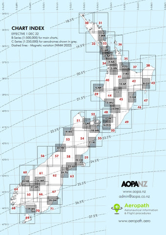
This index illustrates the chart gra...


